
When weather fronts hit the beach
You know that feeling when the forecast promised 20 knots, and the beach delivers 8 knots, then 30 knots, then rain, then you packing your kite like you are defusing a bomb? Congrats, you just met a weather front.
What a weather front really is
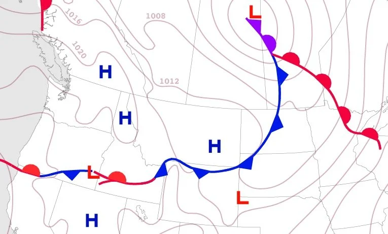
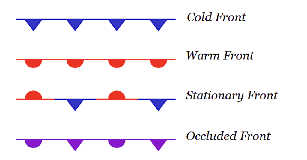
A weather front is basically the border between two air masses that do not get along, usually because they have different temperatures and moisture. Meteorologists literally draw these boundaries on surface maps as warm fronts, cold fronts, stationary fronts, and occluded fronts.
For kitesurfers, the definition that matters is simpler. A front is where the wind mood changes, the clouds reorganize, and the atmosphere decides to either deliver a clean session or throw a tantrum.
Fronts matter because a lot of classic good wind is tied to them. But also a lot of “why is my kite suddenly doing interpretive dance” is tied to them.
How fronts are born and grow
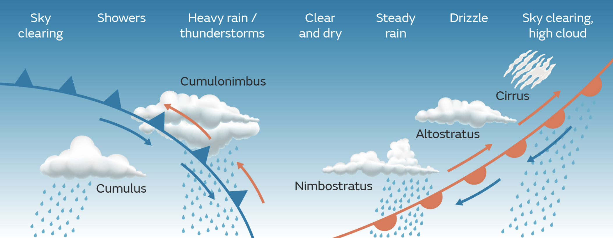
Fronts form because the planet is unevenly heated. The tropics get cooked, the poles stay chilled, and the atmosphere is constantly trying to balance that out. When warm air and cold air meet, they do not neatly mix like a smoothie. Cold air is denser, so it wedges under warm air and forces it upward. Rising air cools, cooling air condenses, and clouds and weather follow.
Now add a low pressure system into the mix. Lows act like atmospheric vacuum cleaners. They pull air inward and make it rotate. Along the edges of these systems, air mass boundaries sharpen and fronts become more active.
A front grows stronger when:
The temperature contrast increases.
The pressure gradient tightens.
Upper level winds support lift.
Moisture is available.
That is why some fronts barely register, while others arrive like a full weather personality crisis.
Cold fronts and the rude wind shift
Cold fronts are where colder air advances and replaces warmer air. On weather maps they are shown with triangles pointing in the direction of movement.
What you feel as a kitesurfer around a cold front:
Before the front, wind often builds and becomes gustier.
At the front, wind direction can shift fast with rain or squalls.
After the front, air cools and wind can either clean up or stay unstable.
Cold front sessions can be unreal or absolutely cursed. Stable air behind the front often brings strong, clean wind. Unstable air brings showers, violent gusts, and kite control roulette.
Common cold front mistake: Riding the average wind like it is a promise. If the forecast says 22 knots with gusts to 32, that gust number is the main character.
Gear tips for cold front days:
Rig smaller than your ego suggests.
Use a kite with solid depower.
Do a full safety system check.
Radar is your friend here. If you want a clear explanation of how to read approaching squalls and rain bands, check out Radar reads: your guide to epic kite sessions.
Warm fronts and the slow sneaky build
Warm fronts happen when warm air moves over colder air. Instead of punching underneath, it glides upward slowly.
For kiters, warm fronts usually mean:
Layered cloud cover.
Longer periods of rain or drizzle.
Wind that can be smoother but lighter or oddly angled.
A classic visual sign is high thin cloud slowly thickening and lowering over time. If you want to get better at reading clouds visually read this Berito article.
Common warm front mistake: Assuming calm equals safe. Warm fronts can bring reduced visibility, messy launches, and gradual wind shifts that sneak up on you mid session.
Stationary fronts and occlusions
Stationary fronts occur when neither air mass wins and the boundary stalls. Weather hangs around and refuses to decide what it wants to do.
Occluded fronts form when a cold front catches a warm front and lifts the warm air off the surface entirely. These systems often combine characteristics of both fronts and bring mixed, unpredictable conditions.
Kiter translation:
Stationary front, Is it wind, is it rain, yes.
Occlusion, The system is evolving and so is your stress level,
How fronts affect your session plan
Fronts directly influence the stuff that makes or breaks a session.
Wind direction: Frontal passages can rotate wind quickly. A safe side onshore setup can turn cross offshore without much warning.
Wind quality: Frontal wind is often gustier due to atmospheric instability. Post front wind can be smoother if the air stabilizes.
Wind strength: Pre frontal build, frontal blast, post frontal drop. All possible in one afternoon.
Clouds and visibility:
High thin cloud increasing, change likely within a day.
Rapid vertical cloud growth, instability building.
Dark rain lines upwind, not the time for hero tacks.
Lightning risk: Thunderstorms are far more common in unstable frontal setups. If you want a solid non-kite specific explanation of fronts and thunderstorm formation, NOAA’s JetStream guide is excellent.
How to spot a front like a kiter
You do not need a meteorology degree. You need a simple routine.
Three layer check:
Synoptic overview using surface maps.
Local conditions at your spot.
Nowcasting with live radar.
Common mistakes that ruin front days:
Launching because it looks fine right now.
Ignoring wind shifts toward offshore.
Rigging big just in case.
Staying out while squalls build upwind.
The sky’s final warning
Weather fronts are not just lines on a map. They explain why some sessions feel effortless and others feel like survival training. When you understand how fronts form and move, you stop being surprised and start making better calls on timing, gear, and safety.
If the wind suddenly changes its personality, congrats, you are probably riding a front, not a forecast.
xox Berito