
Why the wind dies at night, and sometimes doesn't
“ At night the land cools faster than the sea, the daytime thermal switches off, and the wind usually fades. Sometimes the opposite happens, because once thermals stop interfering, bigger pressure systems take over and it builds. Reading your evening wind is the trick to calling a good dawn session.”
Sunset hits, you pack your kite, and suddenly the wind either shuts off like someone pulled the plug or picks up like the beach owes it money. Nighttime is one big atmospheric plot twist. Your kite may be resting, but the air keeps doing its thing. Understanding these after-dark forces gives you a huge advantage, especially when predicting those dreamy early morning sessions that only the dedicated ever catch.
Why does the wind die down at night?
The wind dies at night because the land cools faster than the sea, which switches off the temperature difference that was driving the wind all day. No temperature difference means no pressure difference, and no pressure difference means no wind.
As soon as the sun drops, the surface cools and the daytime thermal slowly stops. The land loses heat faster than the sea. That temperature shift is one of the main reasons your evening wind behaves like it has moods.
Why the wind often fades after sunset:
Less rising warm air, so the pressure difference weakens.
Thermals lose their fuel source.
Turbulent daytime mixing settles, calming gusts.
Cooler land creates a small reverse pressure gradient.
Daytime turbulence settles at the same time, which is why the last hour before the wind dies often feels unusually smooth. The gusts leave before the wind does. If you have ever had a beautiful final twenty minutes and then nothing at all, that is what you were riding.
But this is not universal. In some regions evening wind strengthens because larger pressure systems kick in once the thermals stop interfering. What felt like a light 12 to 14 knots at 6 o’clock can suddenly become a steady 20 knots by 8 o’clock.
If the mechanism underneath all of this is fuzzy, it starts with how wind actually happens.
Is it always less windy at night?
No. Losing the thermal only removes the local wind. It does nothing at all to the larger systems.
If today's wind was mostly thermal, a sea breeze built on local heating, then yes, it will fade after sunset and probably die. If today's wind was coming from a regional pressure system, a front moving through or a big high sitting offshore, then sunset changes very little. The system does not know what time it is.
So the honest answer to "is it less windy at night" is: usually, at thermal spots, in summer. Much less reliably anywhere else. Which spot you are standing on matters more than the hour on the clock, and that is really a geography question.
What is a sea breeze, and when does it actually arrive?
A sea breeze is the daytime cycle: land heats faster than the sea, warm air rises off the land, low pressure forms, and cooler air comes in off the water to fill it. That inbound flow is the wind most of us ride.
It runs to a fairly reliable schedule, which is the useful part:
Starts: a few hours after sunrise, once the land has had time to heat.
Builds: through late morning as the temperature gap widens.
Peaks: mid to late afternoon, when land and sea are furthest apart.
Fades: early evening as the land cools back down
The best sea breeze days share a pattern. Clear sky, a warm land forecast, and a calm morning. A calm morning is a good sign, not a bad one, because it means nothing is competing with the thermal that is about to build. This is the single most common reason people give up on a day that was about to deliver. When the flags start moving around midday, it is go time.
Sea breeze also stacks. If there is already some gradient wind running, the sea breeze adds to it and can turn a marginal forecast into a proper session, sometimes one and a half to two times what was predicted. That is the mechanism behind most days that overdeliver, and it is why Tarifa, Cape Town and the Algarve build through the afternoon rather than starting strong.
The same heating drives thermals further inland, which is why Hood River and Lake Garda produce their best wind late in the afternoon instead of the middle of the day. Mountains and cliffs exaggerate the effect, because there is more surface warming faster.
What is a land breeze?
The sea breeze is the daytime star of many kite spots. But its quieter sibling, the land breeze, takes over at night. When the land cools faster than the sea, the pressure over land becomes higher and air then flows from land toward sea.
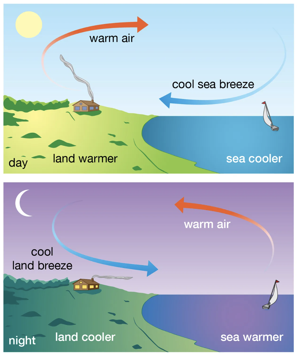
The land breeze is usually weaker, because the pressure difference is smaller than the sea breeze, but it explains a lot of nighttime surprises.
How the land breeze affects evening sessions:
It often brings offshore or diagonal offshore wind.
Wind feels cleaner but carries more risk.
It sometimes masks stronger winds farther out at sea.
It can push warm air upward and create tiny gust pockets near shore.
There is a seasonal pattern here that almost nobody mentions. Land breezes are strongest in autumn and early winter, when the sea is still holding summer warmth and the land is cooling hard overnight. That is exactly the season when the water is coldest and the daylight shortest, which is a poor combination for being blown out to sea.
In light wind locations a land breeze can kill the session entirely. In stronger wind regions it can temporarily twist or bend the direction until the larger system regains control.
Either way, offshore wind deserves its own rules, and I have been blunt about those in offshore wind, sketchy or sendy.
Why does the wind sometimes pick up at night?
Because the daytime churn was getting in the way, and once it stops, the wind above finally reaches the ground.
During the day, heating stirs the lower atmosphere constantly. All that vertical mixing drags the faster air above down into the slower, rougher air near the surface, and the two average each other out. After sunset the ground cools, a stable layer forms, and those two layers stop talking to each other. The air above is suddenly free of surface friction, so it accelerates.
Meteorologists call the result a nocturnal low level jet: a ribbon of faster wind that forms a few hundred meters up, usually strongest somewhere between midnight and just before dawn. Most nights it stays up there and you never know. Some nights it mixes down to the beach, which is why a spot can be dead at eight and honking at eleven.
Reasons nighttime wind can increase:
Daytime thermals stop blocking regional flow.
Cooler and denser air increases, which gives the wind a bigger punch.
Katabatic or drainage wind, where cold air pools on high ground and slides downhill toward the coast overnight.
Cleaner wind at night means the same wind speed feels stronger. A 10m session at 16 knots by day can feel like borderline 9m conditions at night because the airflow becomes silky smooth. Nothing changed except the gustiness.
Why does the wind drop in the evening but not always at midnight?
Because the evening drop and the night wind are two separate events happening in sequence, and people read them as one.
The evening drop is the thermal dying. That is the sea breeze collapsing, and it happens fairly quickly around and after sunset. What comes next depends entirely on what else is available. If nothing else is driving wind at your spot, the evening drop is the end of it and the night stays quiet. If a regional system is sitting there, it takes over an hour or two later, once that stable layer has formed and the low level jet has spun up.
That gap between the thermal switching off and the larger flow arriving is why evening forecasts are the least trustworthy numbers you will look at all day. Models handle the regional scale reasonably well and the local handover between the two badly.
How do you read the night wind for a dawn session?
Look at three things before bed: whether the sky is clear, whether the wind died or held, and which direction it is coming from. Those three together tell you most of what the morning will do.
The logic is simple. A clear night means fast land cooling, which means a big land to sea temperature gap by sunrise, which means a strong thermal once the sun starts working. Cloud cover acts like a blanket and ruins that.
Morning magic does not come out of nowhere. It is built during the night. If you want to predict whether that sunrise session is worth setting an alarm for, watch what happens between sunset and midnight.
| What you see tonight | What tomorrow morning probably does |
|---|---|
| Clear, cloudless, wind died completely | Slow start, then a strong sea breeze building through the morning |
| Cloudy and mild overnight | Weak temperature gap, late or disappointing build |
| Steady offshore flow all night | Healthy land breeze cycle, often flips into a strong onshore thermal after sunrise |
| Evening stayed light with no direction swings | Calm morning, very slow to build, do not set the alarm |
| Wind ramped up late in the night | A regional system is in play, so expect wind early rather than a slow build |
Check once before bed and once before sunrise. The land to sea temperature difference tells you more than the wind number does.
A simple hack is checking live data before bed and again before sunrise. If the night stayed steady and the temperature difference between land and sea increases toward dawn, you are looking at a pretty solid morning session.
Want a full breakdown on reading beach forecasts? Read this one: How to read a kitesurfing forecast.
Do moon phases and tides affect the wind at night?
The moon does not create wind, but it heavily influences tide height and water movement, which in turn affects how wind feels. Full and new moons create spring tides, which are more extreme. That extra water movement interacts with nighttime cooling and airflow.
What moon phases change:
Spring tides move faster, affecting your apparent wind.
Higher high tides at night can amplify chop or flatten the water, depending on your spot.
Strong outgoing tides can reduce perceived kite power.
Strong incoming tides can add helpful resistance under your board.
And moonlight itself? It does nothing to the wind, but it dramatically improves visibility for night riders and reveals more surface texture to read the water, almost perfect for those night time kitesurfing photos.
For reliable tide and moon tracking, NOAA has a clean overview
Is it dangerous to kitesurf at night?
Night riding can feel mystical, but it also hides more danger than you think. Number one is nobody can see you.
The biggest nighttime hazards:
Wind direction flips caused by cooling land.
Growing offshore flow from land breeze.
Incoming tide covering your exit route.
Less visibility of chop, debris or other riders.
Harder self-rescue if the wind drops suddenly.
Misjudging distance because everything looks closer in the dark.
Gear tips if you ever try a moonlit session:
Use bright kite colours, flashlights or reflective stickers on your lines and board.
Wear an impact vest and ideally some flotation.
Know the tide cycle before launching.
Stick to familiar spots only.
Let someone know you are riding.
Never go alone!
Night riding rewards the prepared and punishes the brave who skip steps.
Before you tuck your kites into bed
Night winds and moon tides quietly write the chapter before your morning session begins. Once you know what to watch for, you recognise which evenings signal a strong next day and which evenings predict a slow start. And if you ever choose to ride under moonlight, you will understand exactly why the wind behaves the way it does.
If anyone asks why you are up at 05:30 staring at the flag on the beach, just tell them you have a secret nighttime informant. The wind gossip is strong.
xox Berito
Quick answers
-
Because the land cools faster than the sea after sunset, so the thermal that was driving the wind loses its heat source and the pressure difference weakens.
-
It can be. Cooler, denser night air and the loss of daytime turbulence let larger scale winds take over, and the smoother flow makes the same speed feel stronger.
-
The nighttime opposite of the sea breeze: as the land cools below the sea temperature, air flows from land out to sea, usually lighter and often offshore.
-
Usually at thermal driven spots, yes. If your wind comes from a regional pressure system rather than local heating, sunset changes very little.
-
That is the sea breeze thermal switching off as the land cools. Whether anything replaces it depends on whether a larger system is active at your spot.