
Why are some places windier than others?
“Some places are windier because of three things happening at once: how rough the ground upwind of you is, whether the terrain squeezes the air into a narrower space, and whether anything upwind is blocking it. Water is smooth so wind holds its speed across it, valleys and straits force air to accelerate, and cliffs leave holes in the wind that run for hundreds of meters. Your latitude sets the ceiling. The dune behind you decides what you actually get.”
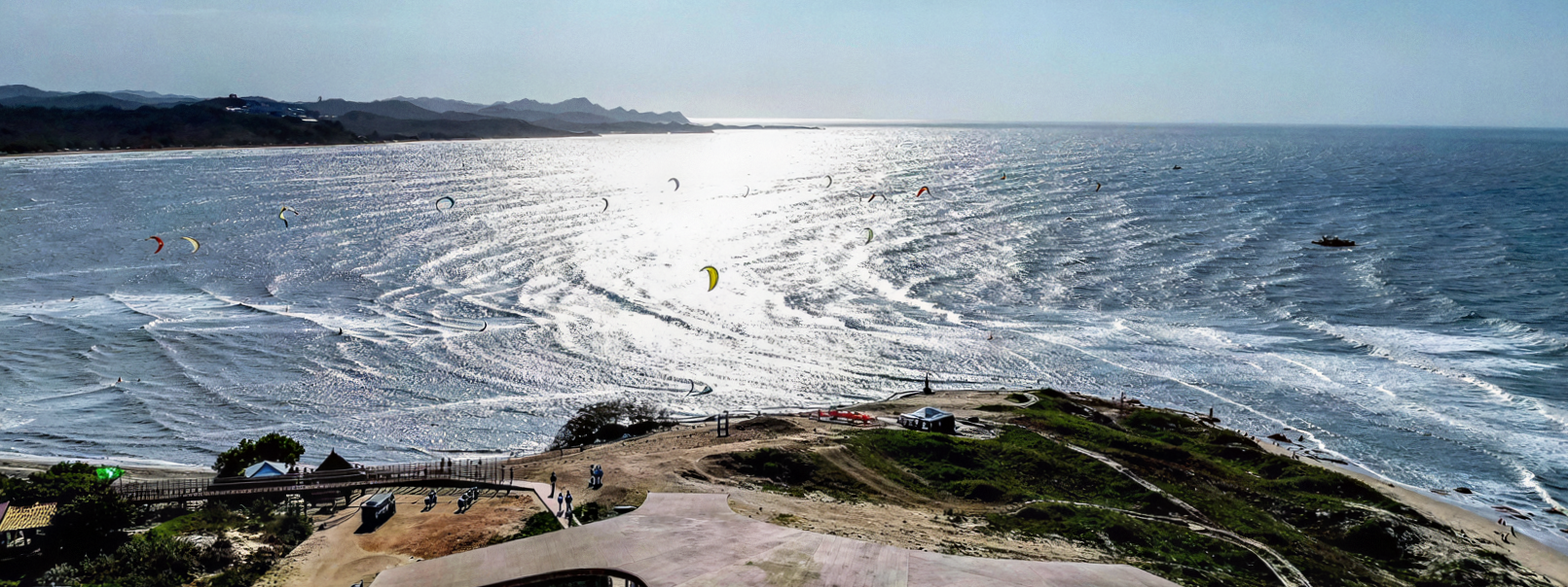
The eternal question: why is it that some spots are blessed with winds so perfect they feel like nature’s gift to kitesurfers, while others leave us staring at limp flags and flat water? The answer lies in a beautiful mix of geography, weather systems, and the quirks of our planet’s atmosphere. Let’s dive in and explore why your favourite kite spots are as windy as they are.
Here is the part that took me embarrassingly long to work out. For about two years I was convinced my local beach was cursed and the forecast was a liar. It was neither. The forecast was fine, the wind was there, and I was standing in the one part of the beach where it was not. Two spots twenty minutes apart share a forecast, a pressure system and a season, and still hand you completely different days. Once you can see why, you stop arguing with your phone and start choosing where to park.
Friction, squeeze and shelter decide everything
Wind loses speed to friction, gains speed when it gets squeezed, and vanishes entirely behind anything solid. Everything else on this page is a variation on one of those three.
Think of air as deeply lazy and extremely easy to bully. Give it a rough surface and it gives up energy. Give it a narrow gap and it panics and speeds up. Put a cliff in front of it and it goes around, sulks for a few hundred meters, and refuses to fill your kite.
Friction is the constant one. Every tree, dune, hedge and roof upwind of you takes a bite out of the flow, and it takes those bites unevenly, which is where gustiness is born.
Squeeze is the generous one. Force the same air through a smaller space and it has no choice but to accelerate, which is the entire business model of Tarifa.
Blocking is the one that ruins sessions. Downwind of anything solid there is a pocket of dead, confused air that is far bigger than it looks.
Friction runs constantly, so it sets your baseline. Squeeze and blocking are the two that change spot to spot, and they are the reason your beach has one glorious direction and three that make you question the hobby. Since all of this happens to wind that already exists, it is worth knowing why air moves at all before you start blaming the landscape, because the landscape is only ever editing something the atmosphere already started.
Are valleys windier than open ground?
Yes, and often dramatically. When wind gets forced through a narrowing gap, a valley, a strait, a channel between two islands, it has to speed up to push the same volume of air through. This is the Venturi effect, and it is the reason some spots casually ignore their own forecast.
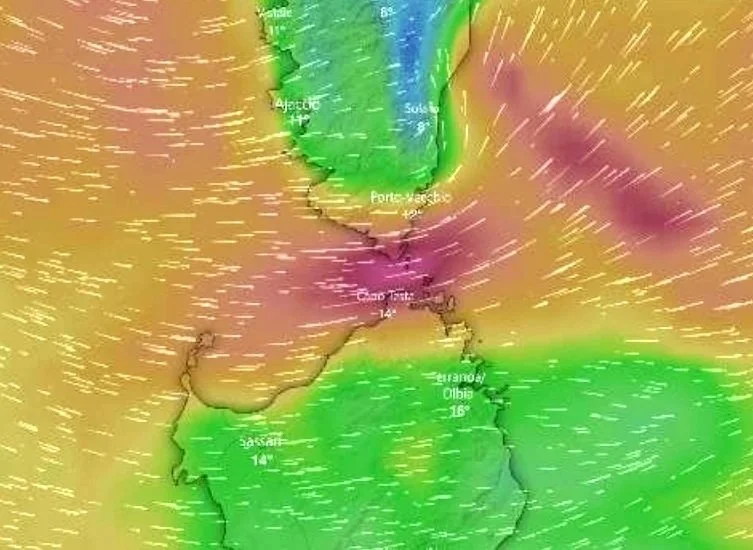
Every famous spot you have ever been jealous of is a funnel of one kind or another:
Tarifa sits at the pinch point of the Strait of Gibraltar with the Atlantic on one side and the Mediterranean on the other, and it accelerates the Levante and the Poniente with equal enthusiasm.
The Corsica to Sardinia channel squeezes wind between two large islands, which is what you are looking at in the screenshot above.
Hood River works because the Columbia River Gorge is a wind tunnel cut clean through a mountain range, which is an unfair advantage and everybody knows it.
La Ventana is hugged by mountains that funnel the north wind straight onto the water, essentially a wind machine built by geology for our specific benefit.
Two things to respect when you ride a funnel. The wind will be stronger than the regional forecast, sometimes by ten knots, so size down before the spot teaches you the lesson itself. And at the far end where the gap opens out, the flow spreads, slows and turns into soup, which is why the exit of a funnel is always messier than the middle.
The best part is that this works at a scale you can walk across. A gap between two dunes, a channel between sandbars, the space between two beach bars. If you have ever found one magic strip of water that is reliably better than everything either side of it, congratulations, you found a small Venturi and have been quietly enjoying it without knowing its name.
Why is it windier near water?
Because water is smooth and land is absolutely not. Wind crossing open water keeps nearly all of its speed. Wind crossing land loses it to every tree, dune, hedge and holiday home it drags over, and it loses it unevenly, which is exactly why it arrives at your kite in lumps.
Which means direction matters more than strength at almost every spot. Same forecast, two completely different days, depending purely on what the wind crossed on the way to you. Wind arriving off the water has had miles of smooth surface to settle down over, so it turns up fast, steady and usually stronger than the number promised. Wind arriving off the land has been through a blender, so it turns up slower, gustier, and at its worst in the first few hundred meters off the beach, which is unfortunately where you are trying to water start.
This is why “my spot is gusty” is almost always the wrong sentence. Your spot is not gusty. Your spot is gusty on the two directions that drag the wind over the campsite first, and glorious on the one that brings it straight off the sea. Since rough ground upwind is what manufactures gusts in the first place, the fix is usually a different day rather than a different kite.
It also explains the inland lake problem. A lake ringed with trees can be genuinely windy in the middle and completely useless at the edges, because wind needs distance to recover after roughness, and you launch from the edge. Working out which directions actually work at your spot is the highest value local knowledge there is, and it costs nothing except paying attention on days you were going to be there anyway.
What is a wind shadow, and how far downwind does it reach?
A wind shadow is the pocket of dead, turbulent air behind anything solid. As a working rule, expect disturbed air downwind for roughly ten to twenty times the height of whatever is blocking it.
That multiplier catches everyone out, so here it is in meters you can actually pace out:
| Obstacle | Rough height | Disturbed air downwind |
|---|---|---|
| Beach building or treeline | 10 m | 100 to 200 m |
| Coastal dune | 15 m | 150 to 300 m |
| Small cliff or headland | 40 m | 400 to 800 m |
| Mountain or island | 300 m and up | Kilometers |
Rule of thumb: disturbed air runs downwind for roughly ten to twenty times the height of whatever is blocking the flow.
A fifteen meter dune can flatten your wind for three hundred meters. That is most of a beach. It is also the reason so many sessions die before they start: you launch in the lee of something, get nothing, decide the forecast lied, and trudge back up the sand with a wet kite and a grudge. The wind was there the whole time. You were standing in the hole.
The versions worth knowing, roughly in order of how likely they are to ruin your afternoon:
Cliffs and dunes are the everyday offender, and the one your home spot is hiding.
Buildings and treelines create the nastiest air of the lot, because the flow does not stop so much as swirl, and swirling air makes your kite behave like it has opinions.
Islands and mountains throw shadows you can see on a map. Table Mountain shades a serious chunk of the bay behind it.
Ships and boats are the moving version, and the genuinely dangerous one. A large vessel passing upwind takes your wind with it for a minute or two, which is fine in open water and considerably less fine near rocks.
The giveaway is on the surface. A glassy patch sitting inside textured water is not a gift of flat water. It is a hole, and your kite will find it before your brain does.
Cliffs and headlands speed the wind up, not down
Air that cannot go through something goes around and over it instead, and it accelerates on the way past. This is the compression effect, and it is the trap sitting on the other side of the wind shadow.
Most riders assume that staying upwind of an obstacle keeps them safe. It does keep you out of the dead air. It also parks you exactly where the wind is being squeezed hardest, so the gust that arrives near the top of a cliff or around the tip of a headland can be a great deal more than the forecast advertised. Being lofted up a beach is not the story you want to be telling later.
There is a gentler relative worth knowing, the bay effect. Wind crossing a wide bay builds as it travels, then compresses as the shoreline narrows toward the head of it. The result is a band of stronger, smoother wind close to shore, which is why some bays are better tight in than they are out in the middle, and why the locals are all riding suspiciously close to the beach.
So the working rule for any spot with real terrain:
Directly behind the obstacle: weakest and most turbulent, this is the hole.
Just around and above it: strongest and gustiest, this is the trap.
Out in the open: honest, and where you should be until you know the spot.
Your kite is in better wind than you are
Friction only reaches so far. The surface slows the air nearest to it, and the higher you go the less it matters. This is the wind gradient, and every rider feels it long before they can name it.
You already know it from three places:
Your kite at the top of the window is sitting in faster, cleaner air than you are.
A jump gets a real boost at the top of its arc, because the kite is climbing into stronger wind.
Landings feel softer than they should, because you are dropping back down into the slow stuff.
The gradient is steeper over rough ground and shallower over open water, so it stacks with everything above. Land upwind gives you a big difference between water level and kite height. Clean water upwind gives you far less. That gap is a large part of why offshore days feel oddly powerful up high and strangely dead down low, which is a combination that flatters your riding and then quietly strands you.
How do you read a spot before you launch?
Stand still for two minutes and look at three things: what is upwind of you, what the water surface is doing, and where the wind is arriving from relative to the beach. That is genuinely most of it, and almost nobody does it because standing still looks like doing nothing.
The water tells you what the forecast cannot:
| What you see | What it usually means |
|---|---|
| Glassy patch inside textured water | Wind shadow, and it will drop your kite |
| Dark, evenly textured water | Clean steady flow, go there |
| Streaks and lines running downwind | Gust lines moving through, expect a punchy session |
| Choppy band close to shore, smoother out | Wind lifting off dunes or a steep beach, you are in a lull near the sand |
| Smooth close in, ragged further out | Offshore flow, much stronger than it looks once you leave |
Two minutes of looking at the water beats any forecast for the next hour.
The land throws in a second set of clues for free. Dune grass bent flat and holding means steady wind rather than gusts. Birds hovering in one place without flapping means lift, so something is pushing air upward there. Sand snaking across the surface means it is stronger than it feels while you are standing there in a hoodie. And two flags disagreeing with each other means you are between two flows, so expect the direction to wander.
Then there is the category of things that have nothing to do with air and will still end your day. Tide state, because plenty of spots only work at one end of the cycle. Depth and what is under it, because low tide reveals rocks, reef and the occasional shipwreck nobody thought to mention. Current, especially near a river mouth, because water moving underneath you changes how much wind you need. And the locals, who already know every word of this and will hand it over for free if you ask before you rig rather than after you swim.
Six spots that cheat, and what they cheat with
The places people save up to visit are almost always places where the terrain is doing something specific. Read this as a set of worked examples rather than a bucket list, because the point is learning to spot the same three shapes at home.
Valdevaqueros and Punta Paloma, Tarifa. The big dune takes the Levante and turns the fan from medium to full send. Routinely far stronger than Los Lances a short drive down the road.
Zandmotor, Netherlands. The man made sand hook south of Scheveningen funnels southwesterly wind over flat shallows, often a few knots better than the main beach. The magic fades once the tide floods, so it rewards showing up at the right hour.
Viento, Hood River. When the Gorge underdelivers, this basalt cliff funnel quietly keeps producing, with smoother gusts and a few knots the Event Site does not get.
Melkbosstrand, South Africa. Just north of the Cape Town circus. Clean ramps, steady southeasterly, and enough space to turn around without apologising to anyone.
Kihei, Maui. Lava fields heat fast and start pulling wind in hours before Kanaha wakes up, which buys you a morning session while everyone else is still queuing for coffee.
Le Morne, Mauritius. Mountains funnel the wind straight into the lagoon, which is the boring structural reason behind every photograph that has ever made you check flight prices.
Every single one of those is a funnel, a heat source or a shelter. That is the whole trick, and your own coastline has at least one of the three hiding on it.
Do some parts of the world simply get more wind?
Yes. Your latitude sets the ceiling and your local terrain decides how much of it reaches the water, which is why a world class wind belt with a badly placed hill still gives you a rubbish afternoon.
Latitude does the heavy lifting. Uneven heating and the rotation of the earth organise the atmosphere into belts, and the trade winds are the useful one. Cape Verde sits inside that belt, which is why the wind there does not really arrive so much as clock in for a shift.
Ocean currents do the next part. Cold water running alongside hot land holds a standing pressure difference in place. The Cape Doctor in Cape Town is powered by the icy Benguela current sitting next to a continent that bakes all summer, which is a fantastic arrangement for everyone except your hands.
Season sets the calendar. Tatajuba in Brazil runs on overlapping trade wind and thermal seasons from July through February, which is about as close to a guarantee as this sport offers. Because the seasonal side of this is really a climate question rather than a terrain one, I have kept it in its own post, and it is worth reading before you book anything long haul.
Daily heating fills in the rest. El Gouna sits in a desert that heats up fast, which fires a dependable onshore thermal most afternoons. The same mechanism runs at your local beach, just smaller and less reliably, and the reason it packs up every evening has far more to do with the land cooling down than with anything the terrain is doing.
None of this makes a bad local spot good. It does explain why the flight to Sal is worth it and the drive to the lake usually is not.
Before you write off your local beach
Most spots that get called unreliable are not unreliable, they are misread. The wind is doing something specific for reasons you can see from the car park, once you know what you are looking at. A dune upwind, a headland off to one side, a direction that drags the air over half a village before it reaches you. None of that is bad luck. It is geography, and geography at least has the decency to stay where you left it.
The genuinely useful part is that this knowledge travels. Once you can look at a coastline and pick out the funnel, the shelter and the hole, you can do it at a spot you have never ridden, in a country you have never visited, on a day when the forecast is doing its honest best and still not telling you the whole story.
Your local beach is probably better than you think on two directions and worse than you think on the rest. Finding out which is a much better use of a flat day than refreshing the app and sighing.
xox Berito
Quick answers
-
Geography and climate: mountains and straits funnel and accelerate wind, ocean currents and trade winds keep it consistent, and land heating creates daily thermal breezes.
-
Reliable, steady wind, usually from trade winds or strong daily thermals, plus terrain that funnels rather than blocks the flow. Tarifa, Cape Town and Cape Verde are classics.
-
Winds created when the sun heats the land, warm air rises and cooler sea air rushes in, giving a predictable onshore breeze that builds through the afternoon.
-
Usually yes. A valley narrows the space the air has to move through, and air that gets squeezed has to speed up. This is the Venturi effect, and it is why straits and gorges produce famously strong wind.
-
Because water is smooth and land is rough. Wind crossing open water keeps its speed, while wind crossing land loses speed and steadiness to every tree, dune and building it passes.
-
As a working rule, expect disturbed air downwind for roughly ten to twenty times the height of the obstacle, so a fifteen meter dune can affect your wind for up to three hundred meters.