
How to read a kitesurfing forecast
“The wind number is the least useful thing on a forecast. What decides your session is the gust spread, the direction, the model behind the numbers and what the sky is doing when you arrive. Windguru gives you the most detail, Windy shows you what is moving, radar shows you what is happening right now, and your own eyes settle the argument. Learn to read the rows around the wind speed and you will stop driving to empty beaches.”
We kiters are a special breed, we check the forecast a lot. Sometimes once a day, sometimes twice, and if we are really desperate for wind, maybe every hour. I have refreshed Windguru at traffic lights. I am not proud of it, but I am also not going to pretend it did not happen.
Here is the thing nobody tells you though. Most of us are reading the wrong number. We scroll to the wind speed, decide yes or no, and ignore the five rows underneath it that actually determine whether the session is good, survivable or a two hour drive to stand on a beach holding a coffee. This is how to read the whole thing.
How do you read a kitesurfing forecast?
Look at five things in this order: wind direction, average wind speed, gust speed, the gap between average and gust, and the time the wind is expected to arrive. Direction first, because the wrong direction makes a perfect wind number useless.
That order matters more than the numbers themselves. A steady eighteen knots side shore is a beautiful day. An eighteen knot average with thirty two knot gusts is a fight, and it is the same eighteen on the app. Since rough ground upwind is what creates that gap, the spread between average and gust is really telling you what the wind crossed on its way to you, which is information the wind speed alone hides completely.
The habit worth building is reading the row, not the cell. One number in isolation tells you almost nothing.
Which forecast app should you actually use?
All three of the big ones are good, and they are good at different things. Windguru gives you the most data in the least space, Windy shows you what the weather is doing as a moving picture, and Windfinder is the easiest to read quickly on a phone. And there are a lot of smaller, more local apps worth exploring.
| App | Best at | Weakest at | Use it when |
|---|---|---|---|
| Windguru | Dense hour by hour detail, gust spread, multiple models side by side | Ugly, and intimidating on your first visit | You are making the actual go or no go call |
| Windy | Seeing systems move, radar layers, wind at different altitudes | Easy to lose an hour to it without deciding anything | You want to understand why the wind is doing something |
| Windfinder | Fast, clean, readable in ten seconds | Less detail, fewer models | You are checking on your phone between other things |
Most riders who go out a lot end up using two: Windguru for the numbers, Windy for the picture.
The honest answer is that most people who ride a lot end up using two. Windguru for the numbers, Windy for the picture. If you only ever open one, make it Windguru, because it is the only one of the three that shows you the gust spread and the model disagreement at a glance.
How do you read a Windguru table row by row?

Windguru looks like a spreadsheet had an argument with a rainbow, and that is exactly why it is good. Every row is one variable, every column is one hour, and once you know what the rows are it becomes the fastest forecast to read on the internet.
| Row | What it is | What to do |
|---|---|---|
| Wind speed | Average wind in knots | Your starting point, never your decision |
| Wind gusts | Peak wind in knots | Size your kite for this, not the average |
| Wind direction | Arrow showing where the wind comes from | Check it against your spot before anything else |
| Wave | Swell height in meters | Matters for launching and landing as much as for riding |
| Wave period | Seconds between waves | Long period means organised swell, short means chop |
| Temperature | Air temperature | Decides your wetsuit, and thermals build on warm land |
| Cloud cover | Percentage | High cover kills thermal wind, clear skies feed it |
| Stars | Windguru's own rating | Useful glance, terrible master |
The gap between wind speed and gusts is the most predictive thing on the page. Under five knots is clean, ten or more is a rodeo.
Two rows deserve more attention than they get. The gap between wind speed and gusts is the single most predictive thing on the page. Under five knots of spread is clean and steady. Ten knots or more and you are riding a rodeo, no matter how nice the average looks.
And cloud cover is the row almost everybody ignores. If your wind is thermal, meaning it builds through the afternoon off warm land, then heavy cloud cover is a session killer even when the wind row looks fine. The sun is the engine. Cover it and the engine stops.
The stars are worth exactly one glance. They are a formula, and the formula does not know that your spot is unrideable at low tide or that the wind arrives two hours late every time it comes from the south. Your own notes will beat the stars within a season.
What wind strength do you actually need?
For most riders on a twin tip, somewhere between fifteen and twenty five knots is the working range. Under twelve you need a very big kite and a lot of patience, and over thirty is a decision rather than a session.
Roughly how it breaks down for an average rider:
Under 12 knots: foil territory, or a very large kite and a light board.
12 to 15 knots: rideable on a big kite, hard work if you are learning.
15 to 20 knots: the sweet spot for most people on most gear.
20 to 25 knots: powered up, smaller kite, properly fun once you are comfortable.
25 to 30 knots: for experienced riders on small kites, and a bad day to be learning.
Over 30 knots: the wind decides, not you.
Bodyweight, kite size and board size all shift these numbers, so treat them as a starting frame rather than a rule. The top of that range is where people get themselves into trouble, and because the line between exciting and stupid moves with your experience rather than sitting at a fixed number, it is worth knowing where yours currently is before a big day tempts you.
Why do two forecasts disagree about the same afternoon?
Because they are running different models, and a forecast is a model output rather than a measurement. Windguru shows you several at once, which is the most useful thing it does and the thing most people scroll straight past.
The two you will see most are GFS, the American global model, and ECMWF, the European one. They are built differently, they update at different times, and they resolve terrain at different levels of detail. When they agree, confidence is high. When they disagree by six knots, the honest answer is that nobody knows yet and you should check again in the morning.
There is a second reason, and it is the one that catches people out on coastlines. Global models work on a grid, and the grid squares are big. Your beach, your dune and your headland are smaller than one square, so the model is describing an average of your whole area rather than the spot you are standing on. Since terrain is what decides how much of that wind actually reaches your beach, a model can be completely right about the region and completely wrong about you.
Evening numbers are the least trustworthy you will look at all day. That is the hour when the local thermal is handing over to the regional flow, and since models handle that handover badly while getting the regional scale roughly right, an evening forecast is often confidently wrong rather than usefully uncertain.
The forecast guesses, the radar knows
A forecast is a guess about later. Radar is a picture of what is in the air right now, which makes it the only tool worth checking in the last thirty minutes before you rig.
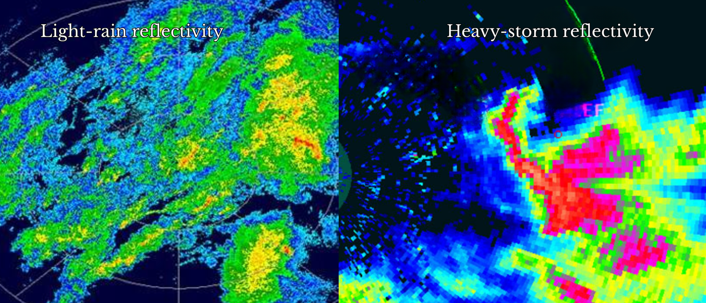
It works by firing microwave pulses at the sky and reading the echo. Two things come back. Reflectivity tells you how much is up there, and velocity tells you how it is moving. Reflectivity is the familiar coloured blob map. Velocity is the one almost no kiter looks at, and it is the more useful of the two.
The colours on reflectivity map to a scale called dBZ, and it translates directly into a decision:
| dBZ | What is falling | Kite call |
|---|---|---|
| 0 to 20 | Very light rain or ground clutter | Usually rideable, keep an eye on it |
| 20 to 40 | Light to moderate rain | Watch visibility, wind may pick up |
| 40 to 50 | Moderate to heavy rain | Gusty, consider landing |
| 50 to 65 | Heavy rain, possible hail | Pack up, safety first |
| Over 65 | Hail core, severe storm | Home time, coffee break |
Every radar app scales its colours differently, so read the legend rather than trusting the colour.
Velocity is read in patterns rather than numbers. Wide, even pastel colours mean laminar, steady breeze. Small bright pockets flashing in and out mean local gusts and lulls. A tight couplet of bright green right next to bright red means rotation, and that means land now and ask questions later.
The best trick with velocity costs nothing: play the animation instead of looking at one frame. If the colours sit still, the wind is smooth. If they strobe like a bad nightclub, it is going to be a rodeo.
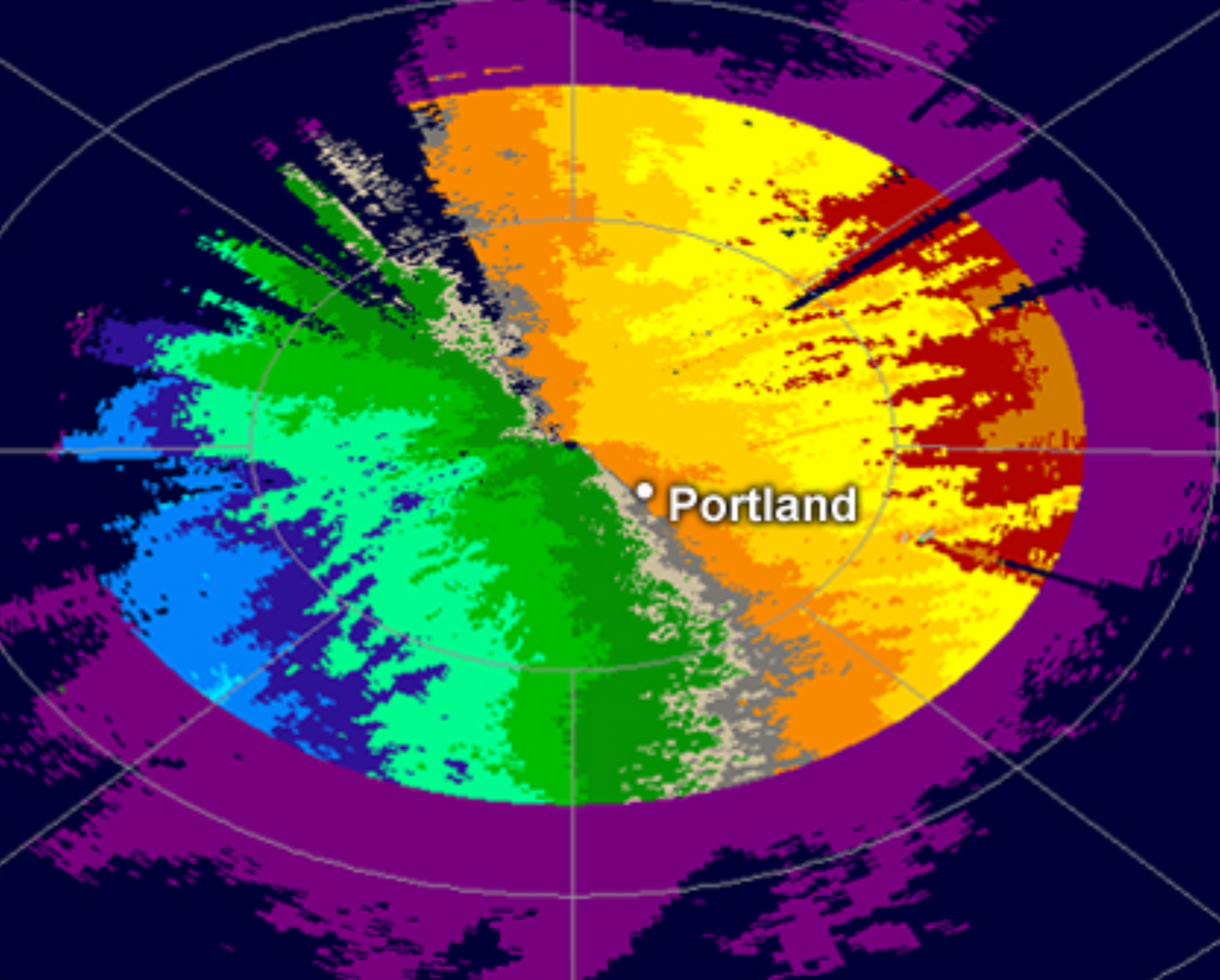
Two limits worth knowing so you do not over trust it. Radar does not see fog, sea spray or fine mist, because there is not enough water to bounce a signal off. And the beam climbs as it travels, roughly a kilometre up at a hundred kilometres out, so if you are far from the station it is looking straight over the top of your low level showers. Always pick the nearest station, and if your spot sits between two, open both.
Spot the squall before it lands on you
Look upwind on reflectivity for a long, narrow band of red or purple. That is a squall line, and if it is upwind of your beach you have minutes rather than hours.
Squall lines usually form along or ahead of a cold front, and they push forward on their own gust front. What arrives with them:
Abrupt wind shifts, often twenty to forty knots in seconds.
Heavy rain and the real possibility of lightning.
A bow echo, where part of the line bulges forward, marking the strongest straight line wind in the whole system.
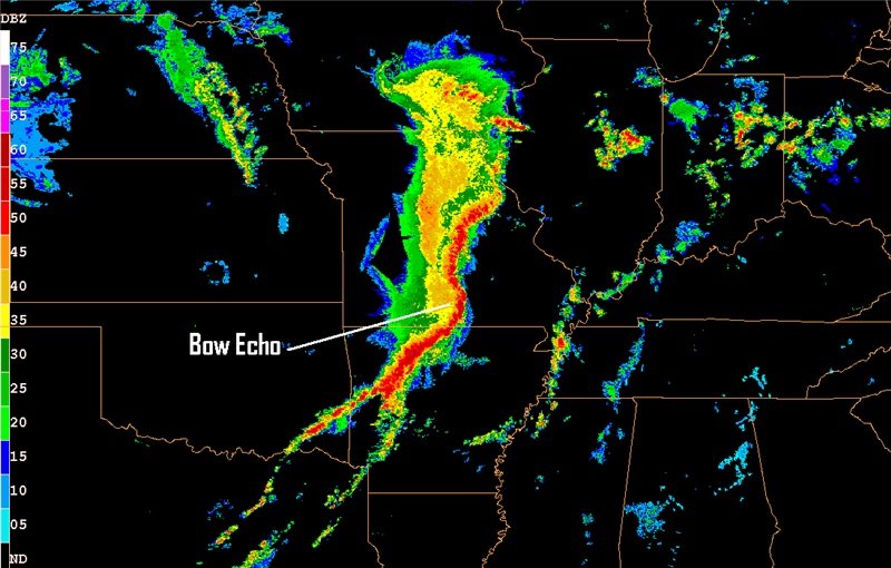
The gust front often runs ahead of the rain as a faint ribbon on the display, which is your warning. It means the wind hits before the water does. If you have ever been on the beach when the temperature drops and the wind swings thirty degrees in ten seconds, that is what passed over you.
The rule is not complicated. Anything red and organised upwind means land the kite and watch it from a café. There is no session worth the alternative, and what a front actually does to your beach is worth understanding before you have to make that call in a hurry.
The sky never goes out of date
The sky is the only forecast that is never out of date. It tells you what is happening at your exact spot right now, which is the one thing a model averaged over a grid square cannot do.
The four that actually matter for a session:
Cumulus, the fluffy popcorn ones. Small, scattered and holding their shape means stable conditions and often a decent breezy afternoon.
Cirrus, the high wispy strands. These are the twenty four hour warning that a system is on its way. Wind is usually coming, and so is the weather behind it.
Cumulonimbus, the towering anvil topped monsters. This is a separate weather system with its own violent wind, and it deserves respect even when it is downwind of you. Gusty wind and a sudden temperature drop as it approaches, then dead air once it passes.
Lenticular, the smooth UFO shaped ones over high ground. Beautiful, and a clear signal of serious turbulence aloft. Hard pass.
Two things to watch beyond the shapes. Cloud bases dropping over an hour or two means pressure is falling and conditions are deteriorating. And high clouds moving in a different direction to low clouds means wind shear, which shows up on the water as a kite that will not behave.
The old sailing line about mares’ tails and mackerel scales making tall ships take in their sails is about exactly this. Cirrus and cirrocumulus, spotted hours before any instrument would have flagged it. People have been doing this without apps for a very long time.
How do you turn all of this into a go or no go call?
Three layers, in order: the forecast picks the day, the radar picks the hour, and your eyes pick the moment. Each one covers what the previous one cannot see.
Here is what that looks like in practice on a real morning:
08:00. Forecast shows eighteen knots side shore. Gust row reads twenty three, so the spread is five knots and it should be clean. Cloud cover is low, which is good news for the afternoon build.
09:00. Radar reflectivity is clear and velocity is uniform pale green. Nothing organised upwind.
09:30. Animation shows a thin yellow band arriving around 11:00. That is the session window defined for you. Rig the 9m, plan two hours.
11:05. First drops, velocity colours spike as the gust front arrives, kites already on the sand. Hot chocolate earned rather than swum for.
The layer most people skip is the third one, and it is the free one. Two minutes of standing still and reading the water surface the way you would read a spot will tell you more about the next hour than any app on your phone, because it is the only source describing the exact patch of water you are about to ride on.
The mistakes that waste the most drives
Reading a single number, and trusting it more than the sky in front of you. Almost every wasted trip traces back to one of those two.
The five that cost me the most sessions before I learned better:
Checking wind speed and ignoring direction. A great number on a bad direction is not a session.
Looking at one radar frame instead of the animation. A still image cannot tell you whether something is arriving or leaving.
Trusting the colours without reading the legend. Every app scales them differently.
Giving up on a calm morning. A quiet morning is a good sign for a thermal day, not a bad one.
Believing the app over the beach. The model is describing a grid square. You are standing on a specific patch of sand.
That fourth one is worth repeating, because it is the most common way people miss a good day. If the forecast says the wind builds in the afternoon and the morning is glassy, that glassy morning is the thermal loading up. Go anyway.
Before you refresh it one more time
A forecast is a starting position, not a verdict. It tells you roughly what the atmosphere intends to do across a fairly large area, and it has no idea about your dune, your tide, or the fact that your spot always overdelivers on a southwesterly.
The riders who consistently score are not the ones with the best app. They are the ones who read the whole row instead of one number, who check the radar before they load the van, and who keep a mental note of what their own spot does when the forecast says a particular thing. That last part takes a season and beats every model on the internet.
Check it, read it properly, then go and look at the water. And if you are refreshing it at a traffic light, at least be honest with yourself about what you are doing.
xox Berito
Quick answers
-
Read five things in order: wind direction, average wind speed, gust speed, the gap between average and gust, and when the wind arrives. Direction comes first, because the wrong direction makes a perfect wind number useless, and the gap between average and gust tells you whether the session will be smooth or a fight.
-
Each row is one variable and each column is one hour. The key rows are wind speed, wind gusts, wind direction, wave height, temperature and cloud cover. Size your kite for the gust row rather than the average, and check cloud cover if your wind is thermal, because heavy cloud stops the heating that drives the wind.
-
Windguru is better for making the decision, because it packs hour by hour detail, gust spread and multiple models into one screen. Windy is better for understanding what the weather is doing, with animated maps and radar layers. Most regular riders use Windguru for the numbers and Windy for the picture.
-
Because forecasts are model outputs, not measurements, and global models work on a grid that is larger than your beach. The model can be right about the region and wrong about your spot, since local terrain decides how much of that wind reaches the water. Different models also disagree, which is why Windguru showing you several at once is useful.
-
They are Windguru’s own rating of how good the conditions look, calculated from wind speed and direction. They are worth a glance but not a decision, because the formula does not know your spot’s tide, terrain or local quirks.
-
Most riders on a twin tip want fifteen to twenty five knots. Below twelve you need a very large kite or a foil, and above thirty is for experienced riders on small kites. Your weight, kite size and board all shift the range.